STEM on Wheels

STEM on Wheels

Tuesday, June 10, 2014

Last Day!


Today's theme was fun! Mrs. Curran and Mr. Grieve planned a trip to the bowling alley today!

8:15 - Rain threatens to cancel our plans for the day. We bide our time by preparing for the exhibition night tonight and watching a movie.

10:00 - We were invited to a sneak peak of 10 Ways to Survive the Zombie Apocalypse. The theater group did an amazing job and it was fun supporting another STEMmersion class!
A must-see show - 10 Ways to Survive the Zombie Apocalypse
11:00 - The clouds begin to part and our chances appear slightly better. Lunch plans are made to eat early in the hopes of leaving soon.

11:45 - After waiting around we decide to brave the weather and go despite the drizzle.
Braving the weather

12:45 - After a short lesson from Mrs Curran the students bowled two games while Mr Grieve enjoys a tasty pizza.

Mrs. Curran explains the rules
Daemon bowling
Josh's first time bowling! And first strike ever!


Mr. Grieve and Mrs. Curran enjoy some pizza
Yusuf and Dena enjoy bowling... maybe?

3:04 - Return to school and do a plus/delta on the course to plan for next year.

Pluses: 

  • Liked biking all over Dayton!
  • Seeing the scenery, historic sites, and spots around Dayton.
  • 95% of the class was biking!
  • Most of the trips were student-planned.
  • Physical exercise was rewarding.

Deltas:

  • Better planning for poor weather conditions.
  • Lots of bike problems - tell students their bikes should be tuned up before class starts.
  • Get a smaller group (if possible).
  • Have a full day of checking bike maintenance.
  • Figure out an average speed the group can travel at and stay together more.
  • Give more planning days to contact trip destinations.
Overall average class score for the course: 4.56/5

Have a great summer everyone!


Geocaching - Group 6

Trip Theme - Geocaching in Dayton

Group Six: Maddie Kelly, Dena Schaeffer, Teagan Findler, Ray Hampton

Destination


E.J. Nutter Park and 2531 Factory Road/Ritter's Frozen Custard

Trip Overview/Things To Do

On this trip we tried to find two geocaches - one at E.J. Nutter Park (N 39° 42.760 W 084° 01.848 ) and another at Ritter's (N 39° 43.044 W 084° 01.777 ). Geocaching is finding an object using coordinates on a GPS that are found on the geocaching website. Before the trip, we learned how to operate a GPS and how to input the coordinates needed. After that, we biked to E.J. Nutter Park to find the geocache and then went to Ritter's on Factory Road. After looking for a while for the "micro" cache, the smallest on the size scale of geocaches, we bought some refreshing ice cream.
Learning how to work the GPS

Directions


1724 Woodman Dr
Kettering, OH 45420
Head north on OH-835 W/Woodman Dr
0.3 mi
Turn left onto Iron Horse Trail
1.5 mi
Turn right onto Creekside Trail
5.9 mi
Turn left


Destination will be on the left
0.2 mi


Map To E.J Nutter Park


EJ Nutter Park
865 Factory Rd, Beavercreek, OH 45434
Head southeast
0.2 mi
Turn left toward Creekside Trail
82 ft
Turn left onto Creekside Trail
0.1 mi
Turn right onto Factory Rd
0.4 mi


This bike ride was mostly smooth and along a straight path. There were occasional obstacles such as sharp curves and slightly steep hills. This trip took about forty-five minutes to the park (because of the accident) and approximately thirty minutes on the way back. 


Most Memorable Experience

Looking for the Geocache at E.J. Nutter Park
Finding the Geocache at Ritter's
We rated this trip a 3/4 because we were only able to find 1 of the 2 geocaches and there was a fall (the accident) on the way to E.J. Nutter Park. Because of this accident, we learned that we should always wear a helmet and make sure the first aid kit stays towards the back of the group. We were only able to find the geocache at Ritter's, but in our opinion, looking for the geocache at E.J. Nutter Park was more fun. The geocache had obviously been moved several times, and we were never able to find it in the end. It was a good team building activity because we had to help each other up into trees, share GPSs, and got to eat ice cream together.
The Accident

Sources Cited

V For... Geocaching. Retrieved from     
      http://www.geocaching.com/geocache/GC3V1BZ_v-for-geocaching

Monday, June 9, 2014

Air Force Museum- Group 1

Trip Theme: Visiting Dayton's Aerospace 

The Theme of our Trip-
This trip is an interesting and captivating trip on the history of the United States Air Force and more. We then be visiting the United States Air Force Museum located in the Wright Patterson Air Force Base.  The museum is relatively close, only adding up to 7.2 miles (14.4 round). As many people know, Dayton is where the Wright Brothers invented and built the first airplane. The airplane has evolved throughout the years; from 1903 to 2014 the plane has been improved and changed dramatically. When we went to the Air Force Museum, it showed us how the airplane improved through many wars and technological advancements.   

Plan For the Day-                                                                                                                        
We left DRSS around 9:00 am and arrived about 10:30. We started with the Wright Brothers plane/era, then we headed to the Space program. We ate lunch at 12:30. We left after lunch which was around 1:00. We then arrived at school around 2:45.The trail that took us to the museum goes through the middle of Riverside, following Woodman Avenue to Airway Road. The trail then took us to the entrance of the museum and base.

Directions-
Google maps link:

Most Memorable Experience- 
We did a lot during our trip, from watching a movie to exploring an old radio tower. Our most memorable experience would have to be the movie. The movie showed and explained what deep space would look like and what the future of astronomy could be. The movie explained the kind of equipment that is used today, like the VLT, which stands for Very Large Telescope. The name stands for exactly what it is, a large telescope can be used to look deep into space. The VLT also uses a laser to focus on a point in space, which nullifies the effects of the atmospheric distortion.

Andrea becomes a pilot!


The group stands in front of a space capsule.

Biking Safety Tip:
Always look both ways when crossing an intersection. This applies to this trip because multiple times we crossed busy intersection, and without this safety tip we would have been hit.

Sources Cited-
"National Museum of the USAF - Home." National Museum of the USAF - Home. N.p., n.d. Web. 03 June 2014.

Friday, June 6, 2014

The Dayton Art Institute - Group 3 Full Day Trip

Trip theme - Dayton Culture

Trip Overview:

This trip to the Dayton Art Institute is entertaining, fun, and challenging. We'd rate this ride 2/4 on a scale of how challenging it is, because it was relatively flat and the roads were nice, but we went on the roads. This ride is also pretty long, 21.4 miles to be exact (round trip), this won't be as long as our 25 mile trip to Xenia or Carillon park but still fairly long.

On this ride we will go to the Dayton Art Institute, and acquire knowledge on the subject of art all over the world. At the Dayton Art Institute we will learn stuff about African art and American art. Within the African exhibit they have Bamileke people sculptures and Nok sculptures. Before we go to the Dayton Art Institute we will stop at the Island Metropark and take a quick break and eat lunch, also do a little sight seeing.  At the Art Institute we will see paintings and look at the difference of paintings throughout the ages, as well as having fun. Being safe is key, try not to split from the group, this will NOT be a straight ride and will be more complicated than a lot of our earlier rides. Pick a buddy and stay near the group! Once all our sight seeing is done we will head back to the school down the same path. 


Here was a pretty funny moment.

Chinese artwork...

They have an extensive collection of Chinese art.

Plan:

Leave school at 10:30 am.
Take the Dayton- Kettering Connector trail to the Buck Creek Trail.
Take the Buck Creek Trail to the Dayton Art Institute.
Eat lunch near Art Institute.
Spend about 2 hours inside of the Art Institute.
Take the same trails back to school.

Total distance is 10.7 miles, and the time it takes to reach there and back is about an hour, going an average of 10-12 mph. Total time is about 4 hours. It is a full day trip because the Art Institute opens at 11:00 am.


Directions: 


Bike on woodman for .3 miles then turn right and take the iron horse trail for 1.5 miles. then continue through the Creek side trail for 2.8 miles, then turn left on the Mad River trail and continue down that trail for 3 miles until you get to the great Miami river trail, where you turn a right on the bridge. Continue down that trail until we get to the Island Metropark, where we will eat lunch and take a break. Then, after lunch we will continue down the trail through E. Helena street until the first fork in bike paths where we will take a right then follow that trail until the very end where it goes through West Riverview Ave. Turn left then right onto Bel
monte Park Ave. until you reach the Dayton Art Institute. Then we're there! Reverse for return to school.


Most Memorable Moment:
Our most memorable experience was seeing the African sculptures. The African sculptures were intricate and beautiful, making this the most memorable part of the trip. After seeing the African sculptures the most memorable and exciting thing we did was most likely the ride there. The ride to the Dayton Art Institute was both beautiful, relaxing, and over all the whole trip was a pretty memorable experience.

Works cited:

The Dayton Art Institute: Art changes Lives... Live it. Retrieved from:
http://www.daytonartinstitute.org/


Thursday, June 5, 2014

Indian riffle park-group 5


TRIP THEME -  Unveiling a Local Gem

Indian Riffle Park


Trip Overview/Things to Do


This trip is a half-day,10.2 mile, 56 minute, round trip ride to Indian Riffle Park

Though Indian Riffle Park may seem like just another public facility at first glance, it is actually unique in a number of ways. Originally getting its name from the “riffles” or "shallow portions in which rocks project from within the local section of the Little Miami River," Indian Riffle Park continues to be a local wonder for all citizens of the area. The park contains many facilities such as a disc-golf course, volley ball courts, shuffle board, football fields, baseball diamonds, concession stands, a playground, as well as a creek and pond for fishing, exploration, or simple relaxation; but perhaps its most intriguing feature is its one-of-a-kind skate plaza that is the first of its kind in the world.

While other “skate parks” are a commodity in the region and across the country, this “skate plaza” is set apart by its professional grade, skill-enhancing design. Nowhere else in the world can skaters (both recreational and pro) find such an authentic, street-themed skate course that utilizes rails,ledges, and ramps in order to provide local skaters a legal place to ride. This 40,000 foot plaza was designed by professional skater and Kettering Native Rob Dyrdek and co-founded by DC shoes, and allows all generations of the Miami Valley community to come together and enjoy their surroundings. 

“The level of support from the city has been huge. Because of the design and the fact that it had never been done before, they had to put a certain level of trust in me. Kettering has bent over backwards to make this happen. The skate plaza is going to be huge for skate boarders as well as the city of Kettering,” said Rob Dyrdek of the Kettering Skate Plaza.

For this, Indian Riffle Park has truly earned the title of a little-known local gem.

Safety Tips

1) Always stay on right side of road when biking through the streets or on a path, except when passing. 
2) Use all appropriate hand signals to let the vehicle around you in on your plan of action.
3) Always wear a helmet and pads.
4) Only ride roller blades or skateboards on the course, other vehicles are not permitted.
5) Once at the park, abide by all skate plaza rules.
Note: Children under the age of 10 are to be accompanied by an adult.
On our way to Indian Riffle Park.

Directions

                                                                      **Note: Iron Horse Trail is also known as Trail 9                                                                                                                                                                                                        


Most Memorable Experience


While at the park, our group engaged in many of the recreational activities Indian Riffle has to offer, including exploring the playground, creek, and skate plaza, walking along the pond, playing cards under the shelter, and most memorably playing 18 holes of Frisbee/Disc Golf. The course took us all around the borders of the park, eventually circling back to our starting point near the playground. During our hour-long game, our small division of eight teamed up to form four partnerships to try and succeed in utilizing the least amount of throws to reach a basket (compatible to a hole in golf) some distance away from the throwing platform. With half the group being first-timers we had our fair share of tree-hitting and bush-landing discs, a couple of times it actually landed in a tree! While this game may not have been one for the record books, it was anything but boring!


Students playing the sixteenth hole.
Students playing an intense game of Egyptian War. (ERS)


Thanks for reading!! 

Sources Cited


"Google Maps." Google Maps. N.p., n.d. Web. 3 June 2014. <https://maps.google.com/maps?       client=safari&oe=UTF8&ie=UTF8&q=Indian+Riffle+Park&fb=1&gl=us&hq=Indian+Riffle+Park&cid=2127876289365004049&ei=3MyMU7fIGMSEqga15IGIDA&ved=0CJoBEPwSMAs>.

"How Did Indian Ripple Road Get Its Name? WYSO Curious Investigates." WYSO. N.p., n.d. Web. 3 June 2014. <http://wyso.org/post/how-did-indian-ripple-road-get-its-name-wyso-curious- investigates>.

"Kettering Skate Plaza." Rob Dyrdek Foundation. N.p., n.d. Web. 3 June 2014. <http://robdyrdekfoundation.org/kettering-skate-plaza/>.

"Unique Skate Plaza in Kettering, Ohio." Yahoo Contributor Network. N.p., n.d. Web. 3 June 2014. <http://voices.yahoo.com/unique-skate-plaza-kettering-ohio-8435829.html?cat=8>.

By: Joel Baker, Lauren Drewing, Joshua Rugwiza, Yusuf Malik, Noah Carrier

Wednesday, June 4, 2014

Westside Park - Group 2 - Xenia, City of Hospitality

Trip Theme - Xenia, City of Hospitality


Trip Overview/ Things to do

We planed this to go to a park in Xenia and The Dairy Station, an amazing ice cream place that most people here liked. This trip was fairly easy because there weren't many ups and downs. This trip was mostly on flat ground so it was a long stretch to where we were heading. There weren't many curves in the path, mostly a straight path. We could see that Xenia really appreciated many bicyclists, as was evident from the good condition of the biking trails.

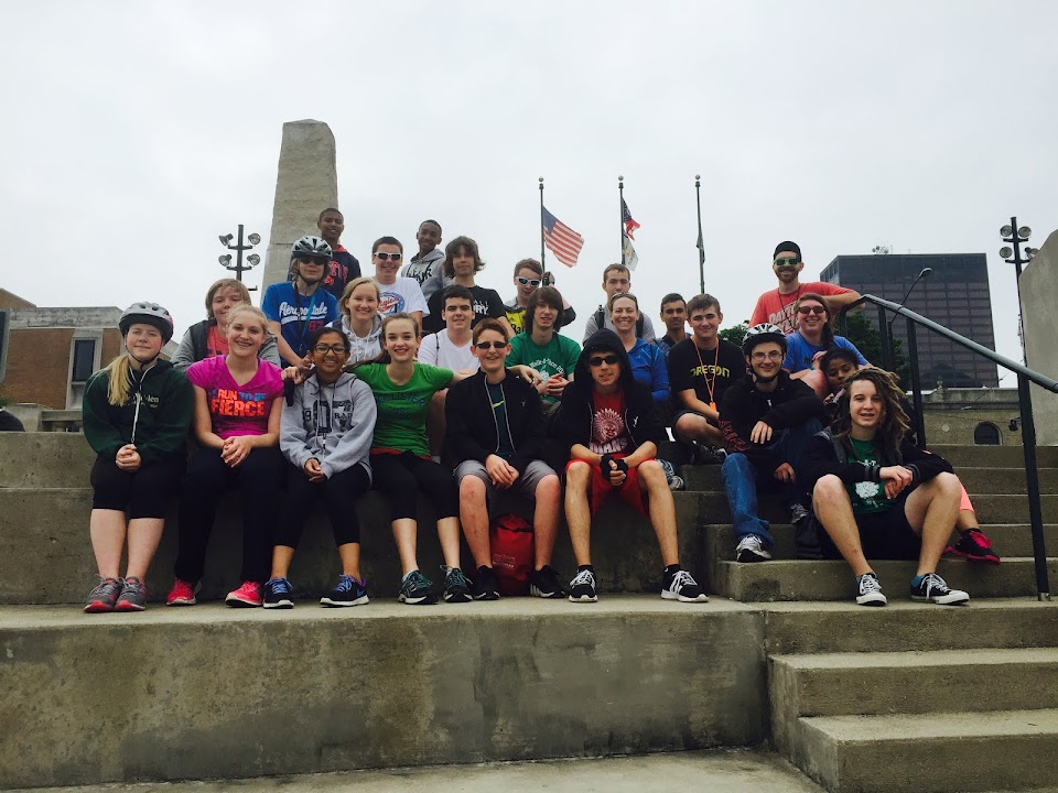
We rode 26 miles total. 13 miles to Westside Park (James Ranch) in Xenia, Ohio and 13 miles back to school. Once we got there we played a class game of kickball until our lunches were brought to us. There were other activities that we could have played such as baseball, play tag, possibly soccer. Then we spent about a half hour eating our lunch at the shelter and playground that was there. After lunch A.J., Ray Hampton's older brother came on Ray's bike to bring Ray his bike and join us in a game of kickball and ice cream. When we finished our lunch, we rode about 2 miles to The Dairy Station and we all had ice cream or milkshakes. Once we got The Dairy Station, our teacher Mrs. Curran, got a free ice cream cone for taking up 28 kids to The Dairy Station.

                              Yusuf about to kick a smasher!       Evan throwing a fast pitch

                                       Our excited crowd             Teagan was a fielder and a cheerleader!

 
                                                 LUNCH!!!                                  Joel sliding to home!!

Ice Cream Break!!!!

One of the things that we could have done while we were at Westside Park, was to find some geocaches around the park. One of the Geocaches you could find is Westside Park- Reborn. Geocaching is defined as "the outdoor sport or game of searching for hidden objects by using Global Positioning System (GPS) coordinates posted on the Internet." Geocaches can be hidden almost everywhere, as long as they are not buried. There are a number of geocaches around Xenia parks, though there are only two at the Westside Park.
 
Day Plan:
  • Leave school at 8:45am
  • Ride 14mi. to Westside Park
  • Play a class game of kickball till 11:30am
  • Eat lunch for a half an hour
  • Bike to The Dairy Station
  • Ride back to school

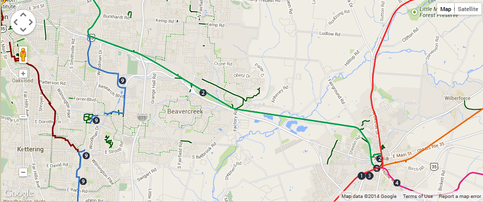
Direction on how to get to Westside Park:
  1. Turn right onto Woodman after leaving school
  2. Continue on Woodman, then turn left onto Iron Horse Trail
  3. Follow Iron Horse Trail past Highway 35, then turn right onto Creek Side Trail
  4. Follow Creek Side Trail for 10miles, then turn right onto Towler Road Spur
  5. Follow Towler Road Spur to Westside Park

 The Green path is the path we took to Westside Park in Xenia.

 Directions to The Dairy Station:
  1. Get on Towler Road spur, follow it to Creek Side Trail
  2. Turn right onto Creek Side Trail, then right onto Towler Road
  3. Turn left onto N West Street
  4. Follow N West Street to W Ankeney Mill Road
  5. Turn right onto W Ankeney Road follow it to The Dairy Station on the right. 
Most Memorable Experiences:
Going to The Dairy Station in Xenia and feeling sick on the bike back from eating too much ice cream. You would imagine that people would get frustrated having thirty young, smelly people in their restaurant, but nobody seemed to get mad at us. I do supposed that it helped that most of us were buying ice cream, but many of us didn't know what we wanted right away. Though, Xenia is the city of hospitality.

Sources Cited: 

"Parks." Xenia City Hall, 2008. Web. 3 June 2014. <www.ci.xenia.oh.us/index.php?page=parks>.

"West Side Park - Reborn." Geocaching.com. N.p., n.d. Web. 3 June 2014. <http://www.geocaching.com/geocache/GC3PWGG_west-side-park-reborn>.

Tuesday, June 3, 2014

Carillon Historical Park Group 4


Carillon Historical Park-A Day of Local Dayton Landmarks

Group Four-Aerin, Ean, Eric, and AJ

Trip Theme - Dayton Landmarks

This trip was an exciting trip that allows you to see many landmarks, such as the Carillon bell tower, the Riverscape fountains, and a few others.  The carillon bell tower is the largest in Ohio with 57 bells.  Riverscape was designed to reunite the Dayton area with a nice park and its fountains.  One of the landmarks in Riverscape is the Wright Flyer.  This was placed to commentate the Wright Brother's first flight. We rated this trip as 3/4 because of the distance that you need to travel, and the slightly hilly trail.

The trail is a relatively nice trail that goes from DRSS to Eastwood Metropark, to Riverscape, and finally to Carillon park.  When you get to each location along the bike path, you can explore and rest there.  When you get to the final destination, you will want to make sure you spend about an hour there, and go into Carillon Park, and look around at all of the historic buildings such as Deed's Barn and Newcom's Tavern.  Deed's Barn is where the Barn Gang, a group of local engineers, including Charles Kettering, met to discuss and design new technological and scientific issues and ideas.  Newcom's Tavern is one of the first buildings built by one of Dayton's first settlers, George Newcom.  It was built in 1796, and was moved to Van Cleve Park in 1896, and then moved to its current location in Carillon park in 1965.

Plan for the Day:
Wright Flyer model at Riverscape.
  1. Leave School at 9:00 a.m.
  2. Take the trails to Riverscape.
  3. Arrive at Riverscape Metro Park at about 10:00 a.m. -play in the fountains and hang out. Spend about 45 minutes at Riverscape before continuing. 
  4. Continue on the Great Miami Trail at about 10:45 a.m.. 
  5. Arrive at Carillon Historical Park at about 11:00 a.m.-play outside, maybe go into the park. (1 hour and a half)
  6. Lunch at Carillon Park at 12:30 p.m. before continuing. (About half an hour)
  7. Begin the trip back to school at about 1:00 p.m..
  8.  Arrive back at school at about 2:15 p.m.
The bell tower at Carillon Park. 

Total Time: Five hours and fifteen minutes or three hundred fifteen minutes

What actually happened:


We left school at 9:08 am and reached Riverscape MetroPark at 10:15 am.  We sat around a while at Riverscape and then moved again. We arrived at Carillon Park at 11:00 am. We played at the park around the bell tower. We were not granted admission into the park itself but we had lunch and resumed our trip around 12:00 pm. After popped tires, brakes malfunctioning, and collisions,  we returned to school at 2:45 pm. 

Ms. Curran smiling after climbing a hill to return to school.

Safety tips: 
  • Always wear a helmet- in case John runs into you.
  • Follow all safety laws- Like not colliding with people on bicycles and obeying red lights. 
  • Carry a bike multi-tool- in case your brakes get too tight or if your pedals become lose. 
Group 4 enjoying Carillon Historical Park
Playing in the fountain on the way back to STEM.


Directions:

Turn right on Trail 9 (Iron Horse trail) from Woodman Drive. 
Take a detour to get to Trail 2 to avoid construction
Take a left onto Spaulding Road.
Take a left onto Linden Avenue.
Take a right onto Spinning Road.
Take a right onto Trail 2.
Turn left on Trail 2 (Creekside Trail).
Turn left on Trail 8 (Madriver trail).
Take the first left on Trail 25 (Great Miami Trail).
Stop at Riverscape along the trail.
Follow Great Miami until Carillon Historical Park.
Click here for the Google map link.
A photo of the Google Maps Image.


Distance to Carillon Park-11.4 miles


Approx. Round trip Distance- 22.8 miles

Actual Round Trip Distance- 25.78 miles
Group Photo time!

Most Memorable Experience:
Aerin-
The bike ride to the park was amazing. The river reflected the sun just the right amount. Downtown Dayton looked pretty in the sun on the Miami Trail. We got to the park and ate. After we ate, I ( Aerin Cornn) blew bubbles around and teenage boys are hilarious when they see bubbles and all shout "BUBBLES!"  Then we heard Twinkle Twinkle Little Star playing from the bell tower. Then we returned to Riverscape and played in the fountains! Beautiful day for a bike ride.
Ean-
When we stopped at Eastwood Park on the way back to STEM, we could not find Mr. Greive or Ms. Curran.  After waiting a few minutes, AJ, Eric, and I decided to go back along the trail to make sure everything was OK with them. After riding over halfway back to Riverscape, we found them pedaling towards us.  We later found out that one of the students had their tire pop, and did not have the right replacement size for it.
AJ-

On the way there we were on the road and we stopped by a cop. This cop then proceeded to drive in front of the oncoming cars and stop traffic for us to pass. Then on the way back the same cop stopped traffic again for us so that we could go.
Eric- 

On the way home I was quite a bit ahead of the group, so I took a little detour onto a super shady BMX track. As I was riding along, there was little blond haired boy just chilling in the middle of the course, randomly. I rode by him and long story short, I flipped over my handlebars. I may never reproduce but it was hashtag worth it.

Sources Cited: 
Carillon Historical Park. Dayton History. Retrieved May 28, 2014, from: http://www.daytonhistory.org/ 

Five Rivers MetroParks. Riverscape MetroPark. Retrieved May 28, 2014, from: http://www.metroparks.org/Parks/Riverscape/Home.aspx 

The Nation's Largest Network of Paved, Off-Street Trails. (n.d.). Miami Valley Bike Trails. Retrieved May 28, 2014, from: http://www.miamivalleytrails.org/nations-largest-network-paved-street-trails
Ryan saving a turtle! Ms. Curran than reminded Ryan to wash his hands.